需同意授權
You're currently viewing an old version of this dataset. To see the current version, click here.

Rice Seedling Dataset 水稻秧苗辨識資料集

Datasets for rice seedling detection model training, validating, testing.

Related Publications

  1. A UAV Open Dataset of Rice Paddies for Deep Learning Practice
    The data descriptor was published on Remote Sensing, MDPI. (open access)

  2. Rice Seedling Detection in UAV Images Using Transfer Learning and Machine Learning
    An application of rice seedling detection using transfer learning was published on Remote Sensing, MDPI. (open access)

MDPI and ACS Style

  1. Yang, M. D.; Tseng, H. H.; Hsu, Y. C.; Yang, C. Y.; Lai, M. H.; Wu, D. H. A UAV Open Dataset of Rice Paddies for Deep Learning Practice. Remote Sens. 2021, 13, 1358. doi:10.3390/rs13071358
  2. Tseng, H. H.; Yang, M. D.; Saminathan, R.; Hsu, Y. C.; Yang, C. Y.; Wu, D. H. Rice Seedling Detection in UAV Images Using Transfer Learning and Machine Learning. Remote Sens. 2022, 14, 2837. doi:10.3390/rs14122837

Contents

  1. Data Download Link
  2. Dataset of Rice Seedling Classification
  3. Dataset of Rice Seedling Detection

1. Basic Data Information

2018 Orthomosaic image

Orthomosaic_Train-Val_Dataset
These three links are the orthomosaic image of paddy No.80, TARI, which were in TWD97 / TM2 zone 121 (EPSG:3826) projection. The images were acquired in three consecutive growing stages in 2018.

Expansion Orthomosaic image (2019-2020)

Orthomosaic_Extended
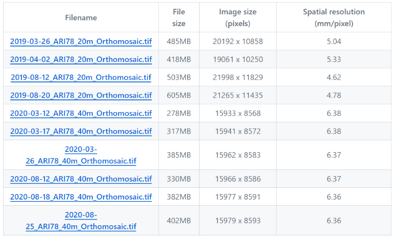
These 10 links are the orthomosaic image of paddy No.78, TARI, which were in TWD97 / TM2 zone 121 (EPSG:3826) projection. The images were acquired in 2019 and 2020.


Dataset of Rice Seedling Classification (Train-Val)

RiceSeedlingClassification.tgz (uncompressed size 426MB)
This file includes two folders: riceseedling and arableland. Train-val and test datasets are all included.


Dataset of Rice Seedling Detection (Train-Val)

RiceSeedlingDetection.tgz (uncompressed size 19.1MB)
This is a PASCAL VOC format object-detection dataset, which includes two folders: JPEGImaegs and Annotations.


Dataset of Detection Demonstration (Test)

RiceSeedlingDemo.tgz (uncompressed size 48.5MB)
This file contains 8 detection demo images and the corresponging PASCAL VOC xml format annotations.


An overview of the region of different datasets

An overview of image dataset
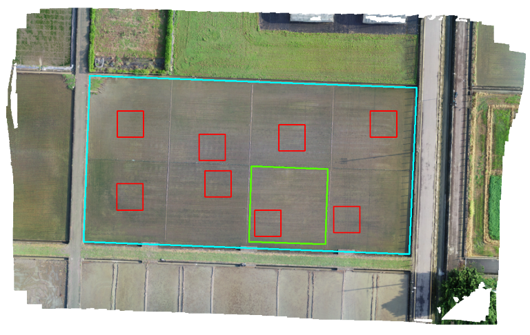
An overview of the field no. 80 (cyan bounding area) in TARI, Taichung. Image acquired on August 7, 2018. The green bounding area represents the area for training-validation dataset, and the red bounding area represents the subsets for object detection demonstration dataset.

2. Dataset of Rice Seedling Classification

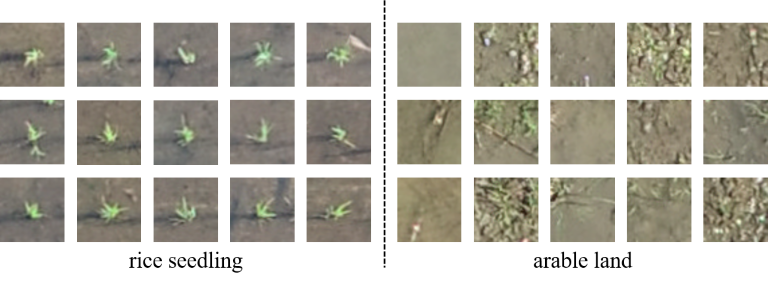
This dataset contains two classes:

  • rice seedling
  • arable land

An overview of image dataset

An overview of image dataset

The number of images used for training, validation, and testing in the rice seedling dataset

Samples of classification dataset

3. Dataset of Rice Seedling Detection

This dataset is used for object-detection model training and validation.

  • PASCAL VOC xml format annotation
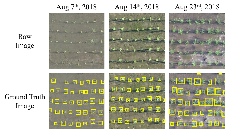
  • 3 consecutive mission: Aug 7th, Aug 14th and Aug 23rd
  • 8 subsets
  • 25 samples/subset
  • 600 samples total

Examples of three growth stages of the rice seedling detection dataset

Examples of detection dataset

Data and Resources

影像檔案

  • RiceSeedlingClassification.tgz TAR

    This file includes two folders: riceseedling and arableland. Train-val and...

  • RiceSeedlingDetection.tgz tgz

    Dataset for rice seedling object detection model training, validation....

  • RiceSeedlingDemo.tgz tgz

    This tgz file contains 8 detection demo images and the corresponging PASCAL...

  • 2018-08-07_ARI80_20m_Orthomosaic.tif TIFF

    Orthomosaic image of paddy No.80, TARI. (in TWD97 / TM2 zone 121 (EPSG:3826)...

  • 2018-08-14_ARI80_20m_Orthomosaic.tif TIFF

    Orthomosaic image of paddy No.80, TARI. (in TWD97 / TM2 zone 121 (EPSG:3826)...

  • 2018-08-23_ARI80_20m_Orthomosaic.tif TIFF

    Orthomosaic image of paddy No.80, TARI. (in TWD97 / TM2 zone 121 (EPSG:3826)...

  • 2019-03-26_ARI78_20m_Orthomosaic.tif TIFF

    Orthomosaic image of paddy No.78, TARI. (in TWD97 / TM2 zone 121 (EPSG:3826)...

  • 2019-04-02_ARI78_20m_Orthomosaic.tif TIFF

    Orthomosaic image of paddy No.78, TARI. (in TWD97 / TM2 zone 121 (EPSG:3826)...

  • 2019-08-12_ARI78_20m_Orthomosaic.tif TIFF

    Orthomosaic image of paddy No.78, TARI. (in TWD97 / TM2 zone 121 (EPSG:3826)...

  • 2019-08-20_ARI78_20m_Orthomosaic.tif TIFF

    Orthomosaic image of paddy No.78, TARI. (in TWD97 / TM2 zone 121 (EPSG:3826)...

  • 2020-03-12_ARI78_40m_Orthomosaic.tif TIFF

    Orthomosaic image of paddy No.78, TARI. (in TWD97 / TM2 zone 121 (EPSG:3826)...

  • 2020-03-17_ARI78_40m_Orthomosaic.tif TIFF

    Orthomosaic image of paddy No.78, TARI. (in TWD97 / TM2 zone 121 (EPSG:3826)...

  • 2020-03-26_ARI78_40m_Orthomosaic.tif TIFF

    Orthomosaic image of paddy No.78, TARI. (in TWD97 / TM2 zone 121 (EPSG:3826)...

  • 2020-08-12_ARI78_40m_Orthomosaic.tif TIFF

    Orthomosaic image of paddy No.78, TARI. (in TWD97 / TM2 zone 121 (EPSG:3826)...

  • 2020-08-18_ARI78_40m_Orthomosaic.tif TIFF

    Orthomosaic image of paddy No.78, TARI. (in TWD97 / TM2 zone 121 (EPSG:3826)...

  • 2020-08-25_ARI78_40m_Orthomosaic.tif TIFF

    Orthomosaic image of paddy No.78, TARI. (in TWD97 / TM2 zone 121 (EPSG:3826)...

  • Unnamed resource

Additional Info

Field Value
Author 曾信鴻
Maintainer 曾信鴻
Last Updated March 21, 2024, 21:06 (+0800)
Created March 19, 2024, 00:26 (+0800)

Recommended Dataset

Rice panicle images and moisture content dataset 水稻跨期作之稻穗影像與穀粒含水量資料集

更新頻率 定期
瀏覽次數 5835
下載次數 0
檔案內容 01_OriginImage 原始稻穗影像圖片 Original images 02_PanicleImage 去背後的稻穗影像 remove background panicle images 03_ColorChecker 校正色卡影像(50x50) color checker images...

作物蟲害多光譜數據集

更新頻率 定期
瀏覽次數 22866
下載次數 5
地理坐標:每個影像的位置信息,通常使用經度、緯度和高度表示,以方便地理信息系統(GIS)的應用。 影像分辨率:指影像中每個像素代表的現實世界中的實際距離。以米為單位表示。 地面樣本距離:指影像中每個像素代表的地面實際距離。以米為單位表示。 影像類型:指影像的類型,如RGB、紅外線等。 拍攝日期和時間:指拍攝該影像的日期和時間。...

作物蟲害管理數據集

更新頻率 定期
瀏覽次數 25336
下載次數 0
拍攝儀器:DJI Phantom 4 Pro 地理坐標:每個影像的位置信息可從內容中查看,以經度、緯度和高度表示,以方便地理信息系統(GIS)的應用。 影像分辨率:影像中每個像素代表的現實世界中的實際距離,可從內容中查看。以米為單位表示。 地面樣本距離:影像中每個像素代表的地面實際距離,可從內容中查看。以米為單位表示。...