
無人機水稻倒伏語意分割影像資料集(2019可見光)
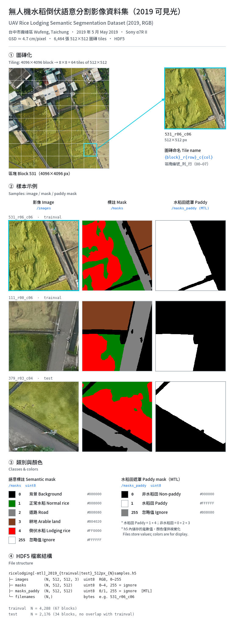
資料集源自國立中興大學農田遙測研究團隊於台中市霧峰區所採集之無人機空拍調查成果。
1. 資料收集與前處理
- 拍攝時期與地點:於 2019 年 5 月水稻成熟期拍攝於台中市霧峰區(主要種植品種為台農71號益全香米)。
- 取像規格:採用無人機搭載高規格全片幅相機(Sony a7R MKII),於天底視角進行航線規劃拍攝,地面解析度達約 4.7 cm/pixel。
- 正射影像拼接:原始空拍照片透過運動恢復結構(SfM)與多視角立體視覺(MVS)演算法生成數值地表模型(DSM),完成幾何糾正並產製全區正射鑲嵌影像。
- 圖磚化規格:將全區正射影像切分為 512x512 像素之標準圖磚,有效圖磚總計達 6,464 張,並封裝為高效能讀寫格式 (HDF5)。
2. 地真標註與類別定義
資料集採用人工逐像元(Pixel-level)精細標註,共定義五大地物類別:
- 倒伏水稻(Lodging rice):受風雨物理侵害致莖稈折斷彎折倒下之水稻區域。
- 正常水稻(Normal rice):直立生長健康之水稻植被。
- 耕地(Arable land):收割後之稻田植被裸地。
- 道路(Road):田間柏油或水泥道路。
- 背景(Background):農舍、建築物、水體或非農田環境雜訊。
3. 資料特性與建議應用
資料集具備真實田間光照變化、田埂交錯及不同倒伏程度之複雜紋理。資料集已設定分層切分(Stratified Splitting),可直接用於卷積神經網路(CNN)或視覺轉換器(Vision Transformer)之訓練與評估,亦可作為多模態/跨年度遷移學習的強健預訓練基底。
4. 資料檔案說明
本資料集提供四個 HDF5 檔案,分為「單任務版」與「多任務(MTL)版」兩組,每組各有訓練/驗證集與測試集。所有圖磚都是從 4096×4096 的研究區塊大圖切成 8×8 共 64 張 512×512 圖磚而來。訓練/驗證集與測試集以區塊大圖為單位切分,兩者之間沒有重疊,可避免相鄰圖磚造成資料洩漏。圖磚名稱格式為 {區塊編號}_r{列}_c{行}(例如 007_r03_c05),存放在各檔案的 /filenames 中。
- ricelodging_2019_trainval_512px_4288samples.h5(約 2.7 GB):單任務版訓練/驗證集,共 4,288 張圖磚,來自 67 幅區塊大圖。包含
/images(RGB 影像,N×512×512×3,uint8)、/masks(五類語意標籤,N×512×512,uint8)與/filenames。驗證集需由使用者自行切出,原論文以隨機種子 42 按 80% 訓練、20% 驗證切分。 - ricelodging_2019_test_512px_2176samples.h5(約 1.36 GB):單任務版測試集,共 2,176 張圖磚,來自另外 34 幅區塊大圖。結構與訓練/驗證集相同,用於模型最終效能評估。
- ricelodging-mtl_2019_trainval_512px_4288samples.h5(約 2.7 GB):多任務版訓練/驗證集。影像、標籤與檔名跟單任務版逐筆相同,另外多一個
/masks_paddy(水稻田二元遮罩,N×512×512,uint8),供多任務學習中的水稻田分支監督使用。 - ricelodging-mtl_2019_test_512px_2176samples.h5(約 1.36 GB):多任務版測試集。內容與單任務版測試集逐筆相同,並附加
/masks_paddy。
使用建議:一般語意分割模型使用單任務版即可;需要水稻田遮罩的多任務模型請使用 MTL 版。MTL 版完整包含單任務版的內容,只需下載其中一組。
5. 引用與授權
- CITATION.cff:Citation File Format 1.2.0 格式的引用資訊檔,記錄資料集名稱、作者、所屬單位、資料集編號與網址、授權條款,以及建議引用之期刊論文。使用本資料集發表成果時,請同時引用本資料集與以下論文:Yang, M.-D., & Tseng, H.-H. (2025). Rule-Based Multi-Task Deep Learning for Highly Efficient Rice Lodging Segmentation. Remote Sensing, 17(9), 1505. https://doi.org/10.3390/rs17091505
- LICENSE:本資料集以「創用 CC 姓名標示 4.0 國際」(CC BY 4.0)授權釋出。使用者可自由重製、散布、修改及建立衍生著作,商業用途亦可;條件是必須標示作者姓名、附上授權條款連結,並註明是否有修改。檔案內含中英文授權摘要與 CC BY 4.0 完整法律條文。
This dataset is derived from UAV aerial surveys conducted in Wufeng District, Taichung, Taiwan, by the Agricultural Remote Sensing Research Team at National Chung Hsing University.
1. Data Collection and Preprocessing
- Acquisition Period and Location: Images were captured in May 2019 during the rice maturity stage in Wufeng District, Taichung, Taiwan. The predominant cultivar in the area is Tainung No. 71 (Yi-Chuan aromatic rice).
- Imaging Specifications: A UAV carrying a full-frame camera (Sony a7R MKII) flew pre-planned routes and captured images from a nadir view, with a ground sampling distance (GSD) of approximately 4.7 cm/pixel.
- Orthomosaic Generation: Structure from Motion (SfM) and Multi-View Stereo (MVS) algorithms were applied to the raw aerial photographs to build a Digital Surface Model (DSM). The DSM was then used for geometric correction to produce an orthomosaic of the entire study area.
- Tiling: The orthomosaic was divided into standard tiles of 512 × 512 pixels. The 6,464 valid tiles are packaged in HDF5 format for fast reading and writing.
2. Ground Truth Annotation and Class Definitions
The dataset was annotated manually at the pixel level, with five land-cover classes:
- Lodging rice: Rice whose stems were broken, bent, or flattened by wind and rain.
- Normal rice: Healthy rice plants growing upright.
- Arable land: Bare paddy fields after harvest.
- Road: Asphalt or concrete roads within the farmland.
- Background: Farmhouses, buildings, water bodies, and other non-farmland areas.
3. Data Characteristics and Recommended Applications
The dataset captures real field conditions, including varying illumination, interlaced field ridges, and complex textures from different degrees of lodging. It has been split with stratified splitting and can be used directly to train and evaluate Convolutional Neural Networks (CNNs) or Vision Transformers. It is also a solid pre-training base for multi-modal and cross-year transfer learning.
4. Data Files
The dataset contains four HDF5 files in two groups, single-task and multi-task (MTL). Each group has a train/validation set and a test set. Every tile comes from a 4096 × 4096 source block, which was cut into an 8 × 8 grid of 64 tiles of 512 × 512 pixels. The train/validation and test sets are split by source block with no overlap, so neighboring tiles cannot leak between them. Tiles are named {block ID}_r{row}_c{column} (e.g., 007_r03_c05), and the names are stored in each file's /filenames dataset.
- ricelodging_2019_trainval_512px_4288samples.h5 (about 2.7 GB): Single-task train/validation set with 4,288 tiles from 67 source blocks. It contains
/images(RGB images, N × 512 × 512 × 3, uint8),/masks(five-class semantic labels, N × 512 × 512, uint8), and/filenames. Users split off their own validation set; the original study used a random 80% / 20% train/validation split with seed 42. - ricelodging_2019_test_512px_2176samples.h5 (about 1.36 GB): Single-task test set with 2,176 tiles from a separate set of 34 source blocks. It has the same structure as the train/validation file and is used for final model evaluation.
- ricelodging-mtl_2019_trainval_512px_4288samples.h5 (about 2.7 GB): Multi-task train/validation set. Its images, labels, and filenames are identical, sample for sample, to the single-task version. It adds
/masks_paddy(a binary paddy-field mask, N × 512 × 512, uint8) to supervise the paddy branch in multi-task learning. - ricelodging-mtl_2019_test_512px_2176samples.h5 (about 1.36 GB): Multi-task test set. It is identical, sample for sample, to the single-task test set, with the addition of
/masks_paddy.
Recommendation: Use the single-task files for standard semantic segmentation models, and the MTL files for multi-task models that need the paddy-field mask. The MTL files contain everything in the single-task files, so you only need to download one group.
5. Citation and License
- CITATION.cff: Citation metadata in Citation File Format (CFF 1.2.0). It lists the dataset title, authors, affiliation, dataset ID and URL, license, and the preferred article citation. If you use this dataset in published work, please cite both the dataset and the following article: Yang, M.-D., & Tseng, H.-H. (2025). Rule-Based Multi-Task Deep Learning for Highly Efficient Rice Lodging Segmentation. Remote Sensing, 17(9), 1505. https://doi.org/10.3390/rs17091505
- LICENSE: The dataset is released under the Creative Commons Attribution 4.0 International License (CC BY 4.0). You may share, adapt, and redistribute the dataset for any purpose, including commercial use, as long as you give appropriate credit, link to the license, and indicate any changes. The file includes a bilingual (Chinese/English) summary and the full CC BY 4.0 legal code.
Data and Resources
影像檔案
-
ricelodging_2019_trainval_512px_4288samples.h5
HDF5
資料集檔案說明(HDF5) ricelodging_2019_trainval_512px_4288samples.h5 任務型態:單任務語意分割...
-
ricelodging_2019_test_512px_2176samples.h5
HDF5
資料集檔案說明(HDF5) ricelodging_2019_test_512px_2176samples.h5 任務型態:單任務語意分割...
-
ricelodging-mtl_2019_trainval_512px_4288samples.h5
HDF5
資料集檔案說明(HDF5) ricelodging-mtl_2019_trainval_512px_4288samples.h5...
-
ricelodging-mtl_2019_test_512px_2176samples.h5
HDF5
資料集檔案說明(HDF5) ricelodging-mtl_2019_test_512px_2176samples.h5 任務型態:多任務(MTL)...
文字檔案
-
LICENSE
中文: 本資料集之授權條款文件。本資料集(含 HDF5 檔案中之影像、標註遮罩與詮釋資料)以「創用 CC 姓名標示 4.0 國際」(CC BY...
-
CITATION.cff
cff
中文: 本資料集之引用資訊檔(Citation File Format 1.2.0...
Additional Info
| Field | Value |
|---|---|
| Author | 曾信鴻 |
| Maintainer | 曾信鴻 |
| Last Updated | October 22, 2026, 22:58 (+0800) |
| Created | September 30, 2026, 18:46 (+0800) |
Recommended Dataset
Rice nutrient, disease and pest symptom image dataset (水稻營養,病蟲害徵狀影像資料集)
更新頻率瀏覽次數
下載次數
作物蟲害管理數據集
更新頻率瀏覽次數
下載次數
作物蟲害多光譜數據集
更新頻率瀏覽次數
下載次數