Rice Seedling Dataset 水稻秧苗辨識資料集
Datasets for rice seedling detection model training, validating, testing.
Related Publications
-
A UAV Open Dataset of Rice Paddies for Deep Learning Practice
The data descriptor was published on Remote Sensing, MDPI. (open access) -
Rice Seedling Detection in UAV Images Using Transfer Learning and Machine Learning
An application of rice seedling detection using transfer learning was published on Remote Sensing, MDPI. (open access)
MDPI and ACS Style
- Yang, M. D.; Tseng, H. H.; Hsu, Y. C.; Yang, C. Y.; Lai, M. H.; Wu, D. H. A UAV Open Dataset of Rice Paddies for Deep Learning Practice. Remote Sens. 2021, 13, 1358. doi:10.3390/rs13071358
- Tseng, H. H.; Yang, M. D.; Saminathan, R.; Hsu, Y. C.; Yang, C. Y.; Wu, D. H. Rice Seedling Detection in UAV Images Using Transfer Learning and Machine Learning. Remote Sens. 2022, 14, 2837. doi:10.3390/rs14122837
Contents
1. Basic Data Information
2018 Orthomosaic image
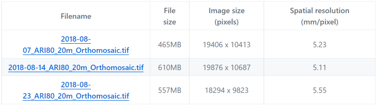
These three links are the orthomosaic image of paddy No.80, TARI, which were in TWD97 / TM2 zone 121 (EPSG:3826) projection. The images were acquired in three consecutive growing stages in 2018.
Expansion Orthomosaic image (2019-2020)
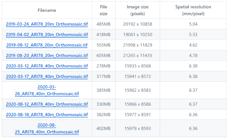
These 10 links are the orthomosaic image of paddy No.78, TARI, which were in TWD97 / TM2 zone 121 (EPSG:3826) projection. The images were acquired in 2019 and 2020.
Dataset of Rice Seedling Classification (Train-Val)
RiceSeedlingClassification.tgz (uncompressed size 426MB)
This file includes two folders: riceseedling and arableland. Train-val and test datasets are all included.
Dataset of Rice Seedling Detection (Train-Val)
RiceSeedlingDetection.tgz (uncompressed size 19.1MB)
This is a PASCAL VOC format object-detection dataset, which includes two folders: JPEGImaegs and Annotations.
Dataset of Detection Demonstration (Test)
RiceSeedlingDemo.tgz (uncompressed size 48.5MB)
This file contains 8 detection demo images and the corresponging PASCAL VOC xml format annotations.
An overview of the region of different datasets
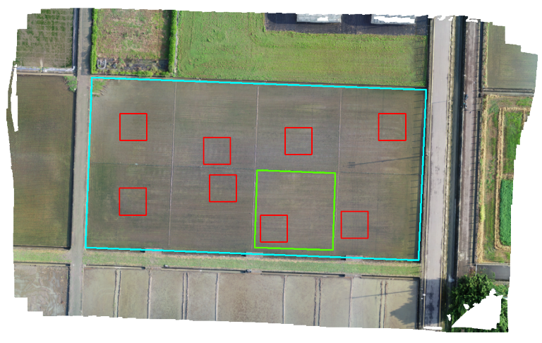
An overview of the field no. 80 (cyan bounding area) in TARI, Taichung. Image acquired on August 7, 2018. The green bounding area represents the area for training-validation dataset, and the red bounding area represents the subsets for object detection demonstration dataset.
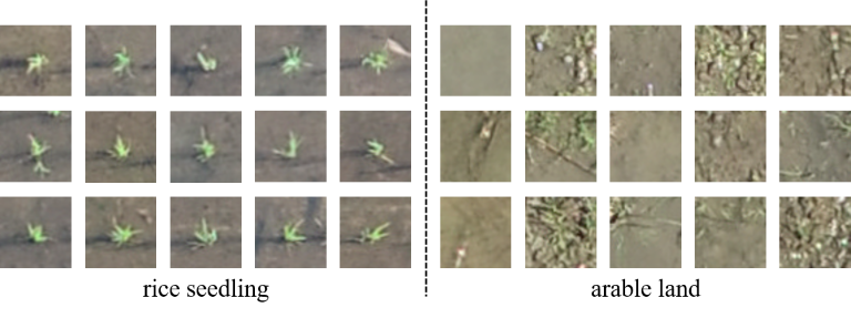
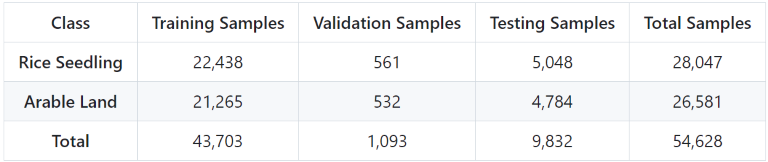
2. Dataset of Rice Seedling Classification
This dataset contains two classes:
rice seedlingarable land
An overview of image dataset
The number of images used for training, validation, and testing in the rice seedling dataset
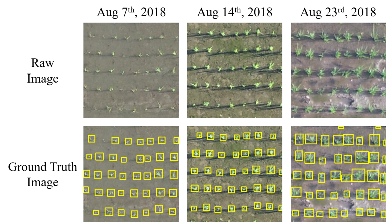
3. Dataset of Rice Seedling Detection
This dataset is used for object-detection model training and validation.
- PASCAL VOC xml format annotation
- 3 consecutive mission: Aug 7th, Aug 14th and Aug 23rd
- 8 subsets
- 25 samples/subset
- 600 samples total
Examples of three growth stages of the rice seedling detection dataset
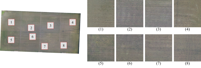
4. Detection Demo Dataset
This dataset is used for patch-based object-detection scenario.
- 8 subsets
- 8m x 8m region
- 1527 x 1527 pixels
- PASCAL VOC xml format annotation
An overview of 8 detection demo images
資料與資源
影像檔案
-
RiceSeedlingClassification.tgz
TAR
This file includes two folders: riceseedling and arableland. Train-val and...
-
RiceSeedlingDetection.tgz
tgz
Dataset for rice seedling object detection model training, validation....
-
RiceSeedlingDemo.tgz
tgz
This tgz file contains 8 detection demo images and the corresponging PASCAL...
-
2018-08-07_ARI80_20m_Orthomosaic.tif
TIFF
Orthomosaic image of paddy No.80, TARI. (in TWD97 / TM2 zone 121 (EPSG:3826)...
-
2018-08-14_ARI80_20m_Orthomosaic.tif
TIFF
Orthomosaic image of paddy No.80, TARI. (in TWD97 / TM2 zone 121 (EPSG:3826)...
-
2018-08-23_ARI80_20m_Orthomosaic.tif
TIFF
Orthomosaic image of paddy No.80, TARI. (in TWD97 / TM2 zone 121 (EPSG:3826)...
-
2019-03-26_ARI78_20m_Orthomosaic.tif
TIFF
Orthomosaic image of paddy No.78, TARI. (in TWD97 / TM2 zone 121 (EPSG:3826)...
-
2019-04-02_ARI78_20m_Orthomosaic.tif
TIFF
Orthomosaic image of paddy No.78, TARI. (in TWD97 / TM2 zone 121 (EPSG:3826)...
-
2019-08-12_ARI78_20m_Orthomosaic.tif
TIFF
Orthomosaic image of paddy No.78, TARI. (in TWD97 / TM2 zone 121 (EPSG:3826)...
-
2019-08-20_ARI78_20m_Orthomosaic.tif
TIFF
Orthomosaic image of paddy No.78, TARI. (in TWD97 / TM2 zone 121 (EPSG:3826)...
-
2020-03-12_ARI78_40m_Orthomosaic.tif
TIFF
Orthomosaic image of paddy No.78, TARI. (in TWD97 / TM2 zone 121 (EPSG:3826)...
-
2020-03-17_ARI78_40m_Orthomosaic.tif
TIFF
Orthomosaic image of paddy No.78, TARI. (in TWD97 / TM2 zone 121 (EPSG:3826)...
-
2020-03-26_ARI78_40m_Orthomosaic.tif
TIFF
Orthomosaic image of paddy No.78, TARI. (in TWD97 / TM2 zone 121 (EPSG:3826)...
-
2020-08-12_ARI78_40m_Orthomosaic.tif
TIFF
Orthomosaic image of paddy No.78, TARI. (in TWD97 / TM2 zone 121 (EPSG:3826)...
-
2020-08-18_ARI78_40m_Orthomosaic.tif
TIFF
Orthomosaic image of paddy No.78, TARI. (in TWD97 / TM2 zone 121 (EPSG:3826)...
-
2020-08-25_ARI78_40m_Orthomosaic.tif
TIFF
Orthomosaic image of paddy No.78, TARI. (in TWD97 / TM2 zone 121 (EPSG:3826)...
-
佚名的資源
額外的資訊
| 欄位 | 值 |
|---|---|
| 作者 | 曾信鴻 |
| 維護者(資料集詢問窗口) | 曾信鴻 |
| 最後更新 | 3月 22, 2024, 17:52 (+0800) |
| 建立 | 3月 19, 2024, 00:26 (+0800) |
推薦資料集
Rice panicle images and moisture content dataset 水稻跨期作之稻穗影像與穀粒含水量資料集
更新頻率瀏覽次數
下載次數
北溝水田多光譜資料集(BeGo Multispectral Field Dataset 2023)
更新頻率瀏覽次數
下載次數
作物蟲害管理數據集
更新頻率瀏覽次數
下載次數